
SYSCAN
GROUND CONTAMINATION SEEKER


SYSCAN is a compact electric vehicle designed for ground contamination monitoring and the detection of radioactive sources, particularly Cesium-137 and Cobalt-60.
Equipped with a high-sensitivity plastic scintillation detector and high-precision GPS tracking, SYSCAN automatically detects, records and geolocates radioactive hotspots.
Its new interactive mapping platform provides accurate visualization of detected hotspots and survey routes, making radiological inspections faster, more precise and easier to analyze.
Designed for easy operation, SYSCAN is available for purchase or rental.
APPLICATIONS
-
Nuclear power plant site inspections for ground contamination detection and GPS-based hotspot localization.
-
Ground contamination monitoring in emergency situations.
-
Soil characterization, remediation and site clearance.
-
Detection of radioactive contamination using a high-sensitivity plastic scintillation detector.
-
Automatic recording and geolocation of radiological measurements.
-
GPS-based survey route reconstruction and interactive radiation mapping.
ADVANTAGES
-
Fast detection and localization of radioactive hotspots across large areas.
-
Very high detection sensitivity, down to < 800 Bq of Cs-137.
-
High-precision GPS positioning with hotspot localization accuracy better than 10 cm.
-
Automatic geolocation and recording of detected alarms.
-
Interactive radiological mapping with color-coded hotspots and vehicle trajectory visualization.
-
Efficient surveys requiring only one operator and one vehicle.
TECHNICAL DATA
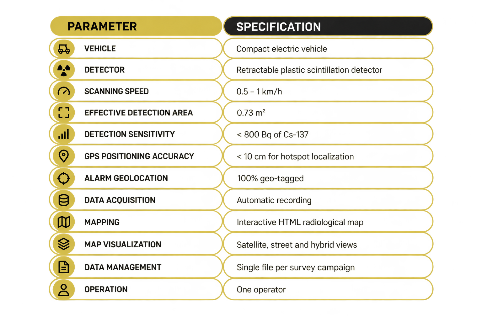

ADVANCED GPS & RADIOLOGICAL MAPPING

SYSCAN’s latest upgrade combines high-precision GPS tracking with an advanced radiological mapping platform, providing a smarter and more efficient approach to ground contamination monitoring.
Radiation measurements are automatically recorded and linked to precise geographic coordinates, enabling accurate hotspot localization with a positioning accuracy better than 10 cm. This automated process eliminates the need for manual position reconstruction, reducing analysis time and minimizing potential errors.
The new interactive mapping interface provides a comprehensive overview of each survey campaign, displaying the vehicle’s complete trajectory alongside color-coded alarm markers based on radiation count rates (cps). Operators can easily explore individual detection points to access detailed information, including count rates, timestamps and GPS coordinates.
Automatically generated in HTML format, the interactive maps can be viewed directly in any web browser, with satellite, street and hybrid views available. All measurement data is consolidated into a single file per survey campaign, simplifying data management, analysis and reporting.
From detection to precise geolocation and interactive visualization, SYSCAN transforms radiological surveys into reliable, actionable mapping data.

